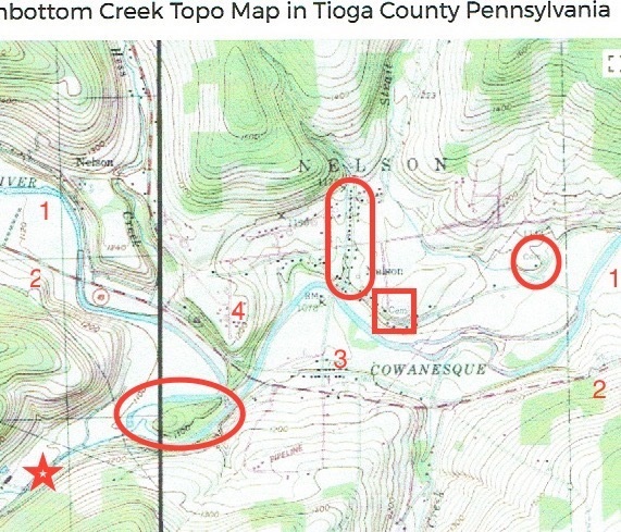
The original map showed things as they were prior to the Cowanesque Lake Project. In the middle of the map, flowing from left to right is the Cowanesque River [identified by #1]. Running beside it is a red, dashed line that's PA Route 49 [identified by #2]. Elkland, PA is just out of sight to the left (upstream). Cowanesque Lake is just out of sight on the right (downstream). The New York State Line is just out of sight above.
The large letters 'NELSON' are for Nelson Twp. Below it, the cluster of little black squares represent the houses of "old Nelson." The vertical row of houses slightly to the left of the 'L' in NELSON is Depot St. [enclosed in the "stadium" shape] (the portion above Lakeview Drive remains). At the bottom of Depot St., along the north bank of the river, is a row of houses which was Nelson's "main drag" before the hamlet's demolition. South of the river, and just above the present PA 49 is another row of houses, which was the old 49 and Nelson's South Side [identified by #3]. '4' marks the location of the Nelson United Church, post office and fire hall.
Samuel Hazlett, Joseph Campbell's son-in-law, purchased his original site form one of the 2 first settlers, Daniel Strait. Early settler Daniel Strait only lived in the area briefly and after he moved on, Sam purchased his land -- 300 acres at $5/acre. If you look above the 'S' in NELSON you will see Strait Creek. If you follow the creek south and east you will see a circle enclosing a house and above it, the word "Cem." That cemetery was the original Campbell family burial ground, later known as the Paul Bennet Cem. Its contents were relocated to the north west corner of the Nelson Cemetery as part of the Cowanesque Lake Project.
The house was at, or near the site of Daniel Strait's cabin and Sam Hazlett's first Tioga Co., Home. He sold the property to his brother John Hazlett. It then went to John's daughter, Eliza HAZLETT Merritt. The property remained in the Merritt family's hands for generations. The last one born in that farmhouse was either Clifford Merritt, Sr. or Gordon Merritt.
The Beecher family settled on a small island in the Cowanesque River for a few years before selling to our Campbells and moving on. Their land and cabin were purchased by John Campbell, Joseph Campbell, and possibly Sam Hazlett.
If you look at the map, south-west of what was once Nelson Borough, and to the left of the word "COWANESQUE," you'll see where PA 49 crosses the river. The river curves south-east and then sharply north-east, forming a "V" that is wooded (green). Just below that is an island of green [enclosed in an oval] that I think was the Beechers' island. Coming to the island, from the south-west, is Thornbottom Creek [marked with a star]. Presumably the expanse of white river bottom land above the island and to the left of the "V" is the location of the "Thorn Bottom" mentioned by Enoch Blackwell Campbell in the minutes of the 1892 Campbell Reunion.
We know that when Sam Hazlett moved from the Strait homestead, he settled at the mouth of Thornbottom Creek, on the left bank and James Campbell on the right bank of the creek. The elder Joseph Campbell apparently settled on the island. John Campbell settled on the river, building a grist mill and a fulling mill. His mill pond came to be known as "Losey's Pond." The younger Joseph lived on the south bank or the river, near the island.
The community that grew up around them was known as Beecher's Island and they church formed in 1844 was the Beecher's Island Presbyterian Church. The first postmaster changed the name to Nelson, but there is no record of why.
For how our ancestors came to Nelson --- and what happened after they arriveed, see Beecher's Island.
At this point we don't know how many acres were purchased from the Beechers. When one of us gets the opportunity to go to the courthouse and examine the earliest tax records and maps we may be able to revise this page to be more specific and more accurate.
[wrtten 10/26/2017]